UPDATED, 2.00 AM PT: One person has died in Florida and there have been two confirmed deaths in Georgia, after Category 4 Hurricane Helene slammed into the U.S. southeastern coast overnight, with winds gusting at 140 mph at its height.
Florida Governor Ron DeSantis said a driver was killed when debris struck their car and warned that other deaths could come to light in the morning.
“When Floridians wake up… we’re going to be waking up to a state where, very likely, there’s been additional loss of life – and certainly, there’s going to be loss of property,” he said. “You’re going to have people that are going to lose their homes because of this storm. So please keep those folks in mind, keep them in your prayers.”
One Florida Sheriff took to social media to warn people not to go out sightseeing.
“As Hurricane Helene makes its way out of Suwannee County we cannot stress this enough: STAY OFF THE ROADS… DO NOT BE RIDING AROUND SIGHT SEEING!”, he wrote
In Georgia, Governor Brian P. Kemp confirmed two deaths in Wheeler County after a trailer was swept up by a tornado.
In an advisory issued by the National Weather Service at 5.00 am ET, the agency said Hurricane Helene had weakened to a tropical storm as it pushed farther inland over Georgia, but warned that life-threatening storm surges, winds and heavy rains would continue.
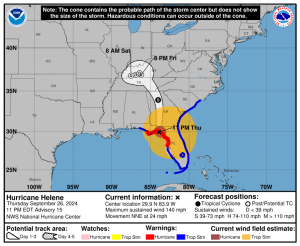
In Florida, there were storm surge warnings for Indian Pass to Bonita Beach and Tampa Bay. A tropical Storm warning remained in effect for mouth of the Suwannee River to Indian Pass, and the Flagler/Volusia county line northward to Little River Inlet
Looking forward, the NWS said Hurricane Helene was expected to continue north over the course of the morning to take its center to central and northeastern Georgia, and then turn northwestward and slow down over the Tennessee Valley later today and Saturday.
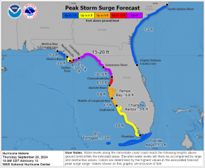
Hurricane Helene originally made landfall shortly after 11 p.m. ET. The storm slammed into Florida’s Big Bend region near Perry with sustained winds of 140 mph and gusts above that, according to the National Weather Service. The associated storm surge has already broken records in the region and the water is still rising due to continuing wind, rain and a rising high tide.
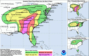
A “catastrophic and deadly” storm surge is expected in northwestern Florida, up to 20 feet in the Big Bend area, along with powerful winds and flash floods hundreds of miles inland across much of the southeastern U.S., according to the National Weather Service. Even as far south as Tampa, a storm surge of 5-8 feet is expected. In addition to the surge, forecasters warn of the wave action on top of that which could compound Helene-related destruction.
One Florida official told the Weather Channel that that Big Bend storm surge is the biggest he’d ever seen predicted there.
Late tonight, the National Weather Service issued a Tornado Watch that covered most of the state of Florida and much of Georgia. That’s about a 460 mile-long stretch from Bonita Springs in the south to Albany in the north.
Helene is now expected to turn northwestward and slow down over the Tennessee Valley on Friday and Saturday.
The storm forced Major League Baseball to reschedule two crucial late-season games between the Atlanta Braves and New York Mets. The hometown Braves are hosting the Mets for the three-game series featuring teams that are neck-and-neck for a playoff spot with just only a handful of games remaining on their schedules.
The two wild-card hopefuls instead will play a doubleheader Monday — one day before the MLB Playoffs start. MLB decided on postponement rather than move the games to a neutral site, which has happened just three times since 2008. The doubleheader will start at 1:10 p.m. ET Monday.
Both Florida MLB teams — the Miami Marlins and Tampa Bay Rays — are playing out of town this week, and neither is in the playoff hunt.
Govs. Brian Kemp of Georgia, Roy Cooper of North Carolina and Ron DeSantis of Florida have declared states of emergency.
The storm’s size adds extra concern. The NWS reports that hurricane-force winds extend outward up to 60 miles from the center and tropical-storm-force winds extend outward up to 310 miles from the center. Per AP, “Hurricane Helene is forecast to be one of the largest storms in seven years to hit the Gulf of Mexico region, according to Colorado State University hurricane researcher Phil Klotzbach. He said since 1988, only three Gulf of Mexico hurricanes have been bigger: 2017’s Irma, 2005’s Wilma and 1995’s Opal.”
As a result, Tropical storm warnings now blanket nearly the entire state of Florida (except where Hurricane warnings are in effect) the entire state of Georgia, the entire state of South Carolina and the mountains of North Carolina. A storm surge warning covers virtually the entire 660 mile long west coast of Florida.
Per NWS, “Weakening is expected after Helene moves inland, but the fast forward speed will allow strong, damaging winds, especially in gusts, to penetrate well inland across the southeastern United States, including over the higher terrain of the southern Appalachians.”

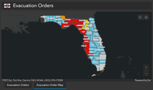
Mandatory evacuations have been issued for parts of Sarasota, Charlotte, Madison, Charlotte, Pinellas, Pasco, Hernando, Citrus, Gadsden, Levy, Dixie, Liberty, Lafayette, Leon and Gulf counties. Mandatory evacuation orders are now in place for ALL portions of Franklin, Wakulla, Hamilton, Hillsborough, Manatee, Suwannee and Taylor counties.

The biggest storm to make landfall in the U.S. in more than a year has the film and TV production hub of Atlanta, aka Hollywood South, in its cross-hairs. Hurricane-force winds are currently expected to extend as far as Macon, GA, which is about 85 miles south of Atlanta. That means Atlanta will likely see tropical storm force winds. On Wednesday, Atlanta was on the edge of an area predicted to have high potential for flash flooding. On Thursday morning, the NWS updated the chart to include Atlanta. See below.

Asked by Deadline early Wednesday whether there are any postponements of film or TV shoots, a rep for the Atlanta Film Office said, “Nothing that we are aware of at this time.”
Over in Orlando, the tornado watch included areas where the Walt Disney World and Universal Orlando resorts are located, according to local Spectrum News 13.
A statement from WDW indicated it had no plans to close the entire resort, but had discontinued some attractions today.
“Walt Disney World Resort is currently operating under normal conditions; however, some experiences will be cancelled or unavailable on September 26,” a Wednesday statement read. “We are closely monitoring the path of the storm as we continue to prioritize the safety of our Guests and Cast Members.”
Among the attractions closed were Disney’s Typhoon Lagoon and the resort’s miniature golf courses. Mickey’s Not-So-Scary Halloween Party was also canceled.
Over at Universal Orlando, the resort’s popular Halloween Horror Night was canceled while Universal City Walk will close early and Volcano Bay was closed for the day.

