iStockphoto
NASA’s Jet Propulsion Laboratory (JPL) scientists recently announced they are developing autonomous underwater robots that they will use to study uncharted areas deep below arctic ice caps.
They are doing this to improve computer models predicting sea level rise by recording more accurate melt rates especially beneath ice shelves.
The challenge: The places where scientists want to measure melting are among Earth’s most inaccessible. Specifically, scientists want to target the underwater area known as the “grounding zone,” where floating ice shelves, ocean, and land meet — and to peer deep inside unmapped cavities where ice may be melting the fastest. The treacherous, ever-shifting landscape above is dangerous for humans, and satellites can’t see into these cavities, which are sometimes beneath a mile of ice. IceNode is designed to solve this problem.
“We’ve been pondering how to surmount these technological and logistical challenges for years, and we think we’ve found a way,” said Ian Fenty, a JPL climate scientist and IceNode’s science lead. “The goal is getting data directly at the ice-ocean melting interface, beneath the ice shelf.”

NASA-JPL
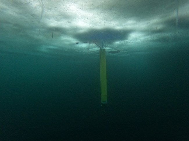
According to a NASA press release, “IceNode’s engineers are developing vehicles about 8 feet (2.4 meters) long and 10 inches (25 centimeters) in diameter, with three-legged ‘landing gear’ that springs out from one end to attach the robot to the underside of the ice. The robots don’t feature any form of propulsion; instead, they would position themselves autonomously with the help of novel software that uses information from models of ocean currents.”
The NASA-JPL Artifical Intelligence Group explains it another way.
“IceNodes are deployed as a swarm from a ship at the shelf edge (or a single borehole), and use variable buoyancy to ride melt-driven exchange currents to high science value landing areas far inside the cavity,” they write. “IceNodes use advanced probabilistic AI guidance techniques and state of the art ocean current models to control their depth to exploit varying current layers such that they are swept below their targets.
“Once underneath their target, IceNodes release a ballast weight to gain high positive buoyancy and attach to the underside of the ice shelf, where they acquire in-situ measurements of basal melt rate directly at the ice-ocean interface for a year or more.
“Finally, IceNodes detach from their landing structure and use variable buoyancy to ride melt-driven exchange currents back to open water, where they surface and transmit their mission data home via Iridium link.”
“If melted completely, Antarctica’s ice sheet would raise global sea levels by an estimated 200 feet (60 meters),” the scientists state. “Its fate represents one of the greatest uncertainties in projections of sea level rise.”

