With over 80 million users, AllTrails is the world’s largest hiking app. For years, the platform has amassed a loyal following of outdoor enthusiasts who use the technology to find local hiking trails, map out routes, and plan trips to national and state parks. But the company just launched a handful of new features that make AllTrails even more appealing to the masses, including one that will definitely rival your weather app.
RELATED: 13 Amazing Benefits of Hiking.
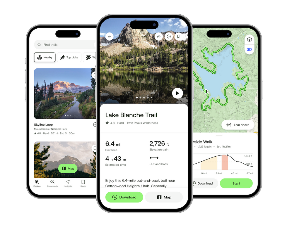
AllTrails just revealed a premium membership plan with 4 new features.
AllTrails
Since its inception in Silicon Valley in 2010, AllTrails has offered its free Base membership, which gives app users access to trail maps, on-trail navigation, and community reviews for more than 450,000 trails around the world.
In 2012, the company introduced its paid Plus membership ($35.99/year), which includes additional features like downloadable maps, photo tours, trail previews, and wrong-turn alerts. Starting this week, Plus members will also get access to Points of Interest, which pinpoints popular and photographable spots, and Offline Areas, a new option to download entire custom areas instead of only trails.
Now, AllTrails just unveiled Peak, a new subscription tier ($79.99/year) that uses AI to power its technologies.
“In building Peak, we developed the most frequently asked-for features from our community, infused them with fun, and powered them with the most advanced technology in the industry. The result is the only app you need for life outside,” said Ivan Selin, chief product officer at AllTrails.
During a recent hiking trip with AllTrails (I now see what all the hype is about!), I learned about the four new features available with a Peak subscription, which will start rolling out in June:
1. Custom Routes
 AllTrails
Whether you want to take a short stroll through your local state park or you’re planning a multi-day adventure itinerary, this feature allows you to map out your own trail route or modify an existing trail. Once you’ve connected the dots of your custom route, the app can use AI to modify it based on the following criteria:
- Reverse direction
- Double back
- Close loop
- Make shorter
- Reduce elevation gain
- Take the scenic route
While you’re in the process of creating your custom route, you can take a photo tour or a 3D preview of the trail to help with your selection. When you’re done, you can save the route, download it, and share it with fellow hikers.
2. Community Heatmap
 AllTrails
Want to avoid a crowded trail on a weekend? Or perhaps you’re hiking alone and prefer a well-populated park? Either way, AllTrails’ new Community Heatmap feature “allows you to see trail traffic data to find popular trails or quieter hidden gems,” as a press release explains.
3. Trail Conditions
 AllTrails
As someone who recently showed up to a rainy-day hike in non-waterproof running sneakers, I’m especially excited about the app’s Trail Conditions feature. It provides weather conditions on the trail, including temperature, precipitation, and snow depth.
4. Outdoor Lens
 AllTrails
Personally, what excited me most about my behind-the-scenes preview of Peak is the Outdoor Lens feature, which is launching for subscribers later this summer. Simply aim your in-app camera at a plant, tree, or flower to identify and learn more about it. These identifications will then be saved in a personal logbook.
In the future, Outdoor Lens is expected to be able to identify mushrooms, insects, and more. And the best part? This tool will work anywhere, from the trail to your neighbor’s garden.
RELATED: The 10 Best U.S. National Parks for Hiking.
How the new weather feature works:
 AllTrails
Back to Trail Conditions, which I think will be a total game-changer, even for non-hikers.
“Functioning as a weather app within the AllTrails platform, Trail Conditions combines analysis of 15 weather factors with geospatial intelligence and recent reviews,” explains the press release, which adds that the feature is powered by more than 10 million data points.
Sure, you can find out about temperature and precipitation from your weather app, but this technology has some really unique features.
For one, it can let you know about mosquito activity on the trail, and as a mosquito magnet myself, this couldn’t be more handy. It also details air quality and sunrise and sunset times. And it lets you preview all of these data points down to the hour and location, so you can know exactly what to expect along your trail route.
A future update will add terrain details (pavement, gravel, mud, etc.) and ground conditions—so you’ll never end up like me with soggy sneakers.
Content shared from bestlifeonline.com.